 par
par James Cook. Né le 27 octobre 1728 dans le petit village de Marton dans le Yorkshire, il était enfant d’une famille très modeste. Malgré une éducation épisodique et sommaire, il démontra dès son jeune âge une facilité remarquable pour l’arithmétique. Bien qu’étant issue d’une classe sociale modeste, son éducation formelle en mathématiques et en navigation fut entreprise sous la protection de son patron John Walker. Il fit par la suite une ascension lente mais constante dans les rangs de la marine britannique jusqu’au grade de capitaine. Il se fit ensuite une renommée lors de ses explorations dans le Pacifique sud. Sa dernière expédition, à la recherche d’un passage autour de l’Amérique du Nord en passant par le Pacifique, se termina abruptement. Lors d’une relâche à Hawaii, en février 1779, il fut assassiné[i] par un indigène.
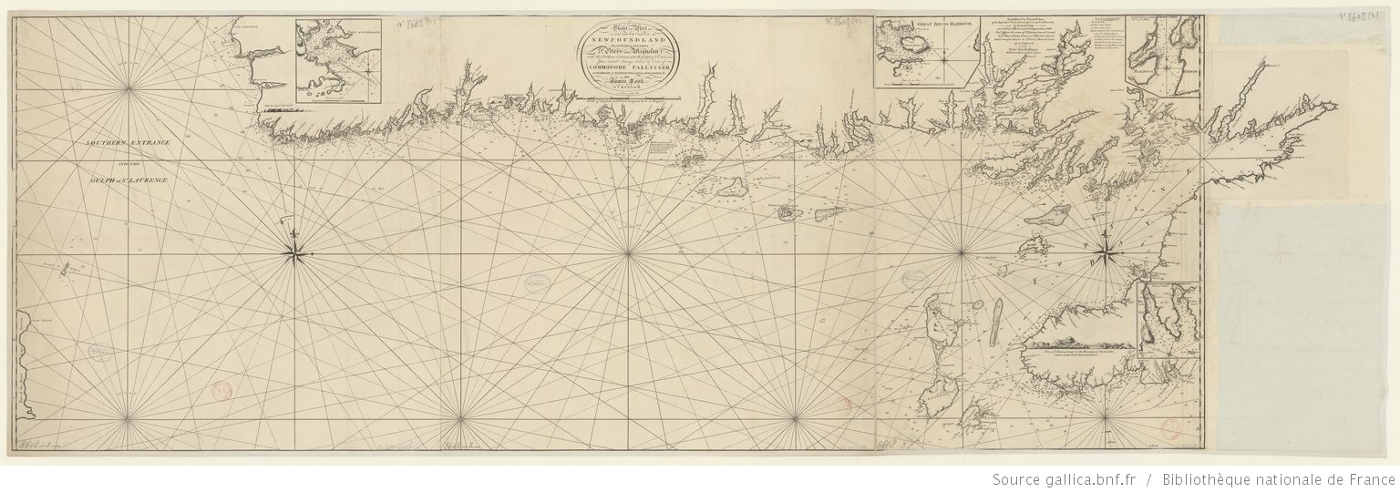
Avant la rétrocession de 1764, les Britanniques décidèrent de lever une carte détaillée des Iles Saint-Pierre et Miquelon. C’était, pour les Britanniques l’ultime chance de cartographier un territoire qui pourrait peut-être devenir hostile. D’autre part, l’amirauté britannique n’avait toujours pas créé un dépôt de cartes comme l’avaient fait les Français depuis 1720. Il était donc impératif pour eux d’établir ces cartes. C’est donc avec précipitation que les ordres furent donnés à James Cook et ses collaborateurs par le capitaine Graves, et aucun délai ne devait retarder la prise de possession par le futur gouverneur d’Angeac.
Mais à peine furent-ils arrivés à Saint-Pierre que les frégates françaises la Licorne et la Garonne se présentèrent dans le port[ii] avec cinquante soldats et cent cinquante hommes, femmes et enfants. Le capitaine Douglas, qui avait pour mission d’aider Cook dans ses travaux, dut alors faire recours à des méthodes diplomatiques multiples pour reporter la date de rétrocession des îles et empêcher le débarquement des français, une tâche qui fut loin d’être facile.
Cook ayant terminé ses relevés sur Saint-Pierre, l’île fût rendue aux autorités françaises le 4 juillet 1763. Il restait donc les îles Miquelon et Langlade à cartographier. Les Anglais décidèrent alors d’entamer des pourparlers interminables sur la nature géographique des îles Miquelon Langlade. Pourquoi ? Celles-ci étant séparées par un bras mer depuis quelques années le capitaine Graves essaya de garder l’île de Langlade sous drapeau anglais. Séparée de Miquelon et proche de Saint-Pierre elle pouvait servir de point stratégique[iii] en cas de nouvelle guerre. Mais ce projet échoua, Langlade et Miquelon furent toutes deux rendues.
Les cartes que produisit James Cook dans des conditions et des contraintes extrêmes furent communiquées à l’amirauté britannique.Outre les cartes et nombreuses épures que nous laissa James Cook, il existe des descriptions très détaillées de chaque coin de l’archipel. Une carte de L’archipel comporte aussi des informations manuscrites. Le texte suivant en est la traduction approximative.
A PLAN of the ISLANDS of St PETERS, LANGLY and MIQUELONG Survey’d by Order of HIS EXCELLENCY THOs GRAVES ESQr GOVERNOR of NEWFOUNDLAND by IAMES COOK
REMARKS
The ISLANDS of St Peters which lies about 6 or 7 Leagues from the nearest part of Newfoundland is very Barren and Mountainous what wood is upon it consists of short small Firs of very little use and difficult to come at. The Ifland is as subject to Fogs as any part in Newfoundland yes if we may credit the late Planters it is very convienient for catching and curing of Codfish there being good fishing ground all around the Ifland, they seldom get lefs than three Hundred Quentata and upwards to a boat in a Summer which in general is reckoned a good Voyage but then it must be observed that they not only had ST Peters, Langley and Miquelong to fish at but all the adjacent Coast of Newfoundland, and as the fish left one Place they followed them to another.
The Road of St Peters is a very bad place for Ships to lay in and fit only for the Summer time, it is but small and the Bottom is everywhere Rocky, the harbour will not admit vefsels of above ten feet draught nor is it capable of holding many of these, they lay sheltred from the weather but the bottom is as much the same as in the Road in every respect this is perhaps one of the worst Harbours about Newfoundland.
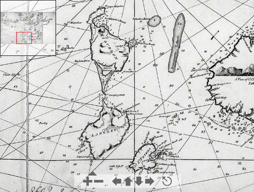
LANGLY is an Ifland of no great value, all the upland being very barren, Swampey and full of Ponds, there is indeed a good deal of weed upon it which consists chiefly of Firs, some of which are 10 or 12 Inches diameter and of a proportionable length large enough for building of Fish Stages flakes…here is likewise great plenty of Black Spruce for Brewing of Beer and some Birch but it is very scarce, down by the the Sound hills near the Langly house is some meadow and Pasture land, where formerly there was a Dairy kept, this Ifland is not a place for Carrying on any Fifhery was there even good fishing ground about it as there is no Harbour, Creek or Cove in the whole Ifland where you can secure a Boat, It is about four years since dame Nature made this a Separate Ifland, before that time it joined to Dunn, but even then it was distinguished by the Name it now bears.
THE ISLAND of MIQUELON, is by much the greatest Part Mountainous and Barren yet with respect to its Soil and Produce it exceeds the other Iflands; that part to the Southward of Dunn Harbour and about the Sand Hills is of a rich sandy soil, and produceth great plenty of good grafs sufficient to maintain several hundred head of Cattle, there is also to be found in several other parts of the Ifland beach peas, beach grafs, and some English grafs; the wood here is of much the same Nature as that on Langly. Nothing drawing more than 5 or 6 feet of water can enter the Harbour of Dunn not Even at high water; as there is always a surf upon the the barr, and is never attempted with anything larger than a fishing Shallo.
The Road of Miquelong tho’ open to the Easterly wind is yet a good Road, where a large Fleet might rendevous wood and water, the only winds that can make s. here is from NE to ESE the force of which must certainly be greatly broke, in rolling over the shoal ground with .. fi…. cured the fish in this road which they get about this Ifland, but of late years it hath not been much practiced, the French talk of making a Harbour of the pond A by cutting a chanel t…the beach which may be practicable.
Green Ifland and the rocks about it, is said to be a good place to fish at but cannot be serviceable for anything else, as there is neither wood nor water on the Ifland or landing place for a boat. Note the tides flow full and change at St Peters, Road of Miquelong and all along the shoar of these Iflands NW and SE and rises and falls upon a perpendicular, Spring Tides 7 feet, Necp Tides four, in the Harbour of Dunn S by E and N by W and rises and falls about 4 feet.
Parmi les noms d’origine anglaise, repris par Fortin notons:
- Gallantry Head : Teste de Galantry.
Utilisation archaïque du mot anglais Gallantry qui signifie d’apparence magnifique ou splendide.Olivier Tulon de la Galanderie, habitant de Saint-Pierre.
- Clives Head : Teste de Clives. L’amiral du port de Saint-Pierre, William Cleeves.
- Cross Point : Pointe à la Croix
- Cape Barnacle : Cap Berniche
- Red Head : la Teste Rouge
- Little Harbour Head : Tête du Petit Havre
- Burial Point : Pointe du Cimetiere
- Pigeon Island : Isle aux Pigeons
- Cuttle Fish Point : Pointe aux Seches
D’autres noms d’origine anglaise seront rapidements abandonnés, parmi ces derniers les toponymes patronymiques :
- Windy Cove : Cap au Diable
- Anderson Point : cap immédiatement au sud de l’Anse à Trehouard
- Point Vincent : Cap à Gordon
- Primrose Point : Pointe à la Loutre
- Curlew Point : Pointe aux Soldats
- Musketa Point : Pointe aux Cheval
- Point Miquelong : Cap Blanc
- Cape Miquelon : Le Cap
- Point Langly : Pointe à la Gazelle
- Woody Cove : Trou au Renard
- Cape Langly : Cap Coupé
- Cape Bay : Anse du Sud Ouest
Saint-Pierre et dépendances
- Island of Columbo : Grand Colombier
- Little Columbo : Petit Colombier
- Cross Pt : Anse à Henry
- Clives head : Cap Blanc
- Cape Eagle : Cap à l’Aigle
- Burial place Pt : Pointe aux Canons
- Harbour : Barachois
- Musele Bank : Ile aux Moules
- Road Island : Ile au Massacre
- Isle Dogs : Ile aux Chiens
- Rasberry Cove : Anse à Trehouard
- Anderson Point : cap immédiatement au sud de l’Anse à Trehouard
- Point Vincent : Cap à Gordon
- Pigeon Island : Ile aux Pigeons
- Boar Island : Ile aux Vainqueurs
- Corneal Rocks : les Canailles
- Sleep Rocks : Rocher Plat
- Great Black Rock : Ilot Noir
- Little Black Rock : l’Enfant Perdu
- S. E. Point : la Pointe
- Gallantry Cove : Anse à l’Allumette, Anse à Philibert
- Cronier Point : Cap Noir
- Gallantry Head : Tête de Galantry
- Little Harbour : Petit Havre
- Little Harbour Head : Pointe Blanche
- S. W. Cove : Anse à Ravenel
- Red Head : Pointe aux Basques
- Cape Barnacle : Pointe du Diamant
- Barnacle Pond : Etang de Savoyard
- Cuttle Fish Point : Pointe de Savoyard
- Windy Cape : Cap au Diable
- Gull Pond : Etang Goéland
Langlade
- Langley Gut : Passe de la dune
- Langley House : maison sur l’Isthme de Langlade
- Seal Cove : Anse du Gouvernement
- Deadmans Cove : Anse aux Soldats
- Percee Point : Cap Percé
- Percee Island : Rocher de l’Hôpital
- Percee Cove : Anse à Ross
- Point Langly : Pointe à la Gazelle, Cap à Ross
- Woody Cove : Trou au Renard
- Cape Langly : Cap Coupé
- Cape Bay : Anse du Sud Ouest
Miquelon
- Primrose Point : Pointe à la Loutre
- Curlew Point : Pointe aux Soldats
- Musketa Point : Pointe aux Cheval
- Point Miquelong : Cap Blanc
- Cape Miquelon : Le Cap
- Road of Miquelong : Anse de Miquelon
- Point Chapeau : Pointe du Chapeau
- Shappo : le Chapeau
- Green Point : Pointe aux Alouettes
- Miquelong Rocks : Rochers de l’Est
- Dunn Harbour : Grand Barachois
[i] Malheureseument, après sa mort, sa femme détruisit un grand nombre de ses documents personnels incluant sans doute des notes sur les îles Saint-Pierre et Miquelon.
[ii] Les îles devaient être rendues au plus tard le 10 juin 1763. Cook, et Davis arrivèrent à St Pierre le même jour que les français, vers le 14 juin 1763. Beaglehole, J.C. The Life of Captain James Cook. Chapitre 4, pp 71. Stanford University Press, 1974.
[iii] Beaglehole, J.C. The Life of Captain James Cook. Chapitre 4, pp 71. Stanford University Press, 1974.
Note : cette série d’articles fut rédigée entre 1997 et 2004 dans le cadre d’une œuvre consacrée à l’histoire de la cartographie et de la toponymie de l’archipel. Le projet n’ayant abouti, les ébauches vous sont livrés tels quels avec pour seul objectif de mieux faire connaître cette facette particulière de notre histoire.
Cartographie et toponymie des îles Saint-Pierre et Miquelon.
De William Taverner à James Cook 1721 – 1764
James Cook